|
|
|

This case study shows how even in the present day earthquakes are still as damaging and still as unpredictable as they were back in 1989. Nepal suffered a major earthquake also known as the Gorkha earthquake on April 25th at 11:56 (local time) at a magnitude of 7.8/8.1 magnitude and a mercailli intensity of violent
Nepal lies towards the southern limit of the diffuse collisional boundary where the Indian Plate under thrusts the Eurasian Plate occupying the central sector of the Himalayan arc, nearly one-third of the 2,400 km (1,500 mi) long Himalayas. Geologically, the Nepal Himalayas are sub-divided into five tectonic zones from north to south, east to west and almost parallel to sub-parallel. These five distinct morpho-geotectonic zones are: (1) Teral Plain, (2) Sub Himalaya (Silvalik Range), (3) Lesser Himalaya (Mahabharat Range and mid valleys), (4) Higher Himalaya, and (5) Inner Himalaya (Tibetan Tethys). Each of these zones is clearly identified by their morphological, geological, and tectonic features. The convergence rate between the plates in central Nepal is about 45 mm (1.8 in) per year. The location, magnitude, and focal mechanism of the earthquake suggest that it was caused by a slip along the Main Frontal Thrust. 12th May 2015 Aftershock: A major earthquake occurred in Nepal on 12 May 2015 at 12:50 pm local time (07:05 UTC) with a moment magnitude of 7.3, 18 km (11 mi) southeast of Kodari. The epicenter was on the border of Dolakha and Sindhupalchowk, two districts of Nepal. This earthquake occurred on the same fault as the larger magnitude 7.8 earthquake of 25 April, but further east than the original quake.[1] As such, it is considered to be an aftershock of the 25 April quake.[1] It struck at a depth of 18.5 kilometres (11.5 mi). Shaking was felt in northern parts of India including Bihar, Uttar Pradesh and West Bengal. Tremors were felt as far as about 2400 kilometers away from the epicenter in Chennai. - Minutes later, another 6.3 magnitude earthquake hit Nepal with its epicenter in Ramechhap, east of Kathmandu. The earthquake was felt in Bangladesh, China and many other states in India. The impact of these tremors was felt even 1,000 kilometres away in the Indian capital New Delhi, where buildings shook and office workers evacuated. - This aftershock caused even more panic due to the high numbers of people living out in the open air due to the first earthquake. There was mass panic and added injuries. |
Impacts:
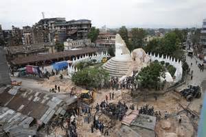
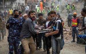
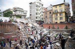
- The epicentre was east of the district of Lamjung, and its hypocentre was at a depth of approximately 15 km (9.3 mi). It was the worst natural disaster to strike Nepal since the 1934 Nepal-Bihar earthquake. - The earthquake triggered an avalanche on Mount Everest, killing at least 19, making April 25, 2015 the deadliest day on the mountain in history. The earthquake triggered another huge avalanche in the Langtang valley, where 250 people were reported missing. - There was continued aftershocks throughout Nepal at 15-20 minutes intervals, with one aftershock reaching a magnitude of 6.7 on 26th April at 12:54. - Hundreds of thousands of people were made homeless with entire villages flattened, across many districts of the country. Centuries-old buildings were destroyed at UNESCO World Heritage Sites in the Kathmandu Valley, including some at the Kathmandu Durbar Square, the Patan Durbar Square, the Bhaktapur Durbar Square, the Changu Narayan Temple and the Swayambhunath Stupa. Geophysicists and other experts had warned for decades that Nepal was vulnerable to a deadly earthquake, particularly because of its geology, urbanization, and architecture. - Thousands of houses were destroyed across many districts of the country, with entire villages flattened, especially those near the epicentre - Disruption to the airport: it was closed the earthquake but reopened to assist in rescue and aid missions. However, was later shut down again for the fear of damage and safety for planes entering the area. - Concern was expressed that harvests could be reduced or lost this season as people affected by the earthquake would have only a short time to plant crops before the onset of the monsoon rains. -Nepal, with a total Gross Domestic Product of USD$19.921 billion (according to a 2012 estimate), is one of Asia's poorest countries, and has little ability to fund a major reconstruction effort on its own Rescue and Relief: - About 90 percent of soldiers from the Nepalese Army were sent to the stricken areas in the aftermath of the earthquake under Operation Sankat Mochan, with volunteers mobilized from other parts of the country - Rainfall and aftershocks were factors complicating the rescue efforts, with potential secondary effects like additional landslides and further building collapses being concerns. Impassable roads and damaged communications infrastructure posed substantial challenges to rescue efforts - Survivors were found up to a week after the earthquake British People: http://metro.co.uk/2015/04/28/how-google-person-finder-is-helping-trace-people-missing-in-nepal-5170377/ This Link is an example of the efforts to find British and Irish people believed to be missing or feared dead in Nepal. Increasing numbers used social media and google person finder as a way to make contact and ensure the safety of their loved ones. |
